Credito:CC0 Dominio Pubblico
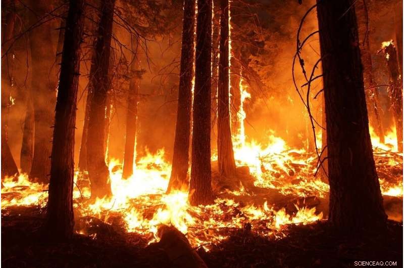
Tutto ciò che servirà perché il Texas centrale diventi la prossima area inghiottita da catastrofici incendi come quelli visti in Australia è una primavera e un'estate secche, una fiamma errante e venti sostenuti.
I vigili del fuoco della contea di Travis affermano che la probabilità di un tale mega-incendio è solo una questione di tempo.
Un recente rapporto pubblicato da CoreLogic, un servizio di dati immobiliari online, Austin è al quinto posto tra le aree metropolitane della nazione più a rischio di incendi. Gli unici altri nel paese a maggior rischio sono in California, secondo lo studio.
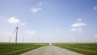
Mentre il mondo osserva e piange la devastazione degli incendi che affligge l'Australia, i residenti devono solo guardare fuori dalla finestra per vedere un paesaggio simile che gli australiani ammiravano prima dell'inizio degli incendi.
Daniele Shaw, un australiano che ha lavorato per il National Weather Service come osservatore di tempeste, ha detto che anche il suo paese d'origine è stato costruito sul retro di aree protette come le terre selvagge di Austin a ovest.
E, simile alla crescita residenziale vicino alle aree erbose a est dell'Interstate 35, la crescita della popolazione in Australia ha anche spinto i quartieri sempre più vicini alle praterie selvagge.
Shaw ha detto che se le terre selvagge di Austin prendono fuoco e le braci soffiano in quelle praterie, i vigili del fuoco avrebbero lottato per spegnere le fiamme prima che un altro si accendesse nelle vicinanze.
"Se hai carburante da bruciare e vento per guidarlo, allora avrai un fuoco veloce che si tratti di praterie o cespugli, "Ha detto Shaw.
Bob Nicks, presidente del sindacato dei vigili del fuoco di Austin, ha detto che la mancanza di vento sostenuto di Austin è ora l'unica cosa che protegge Austin da un destino simile.
Però, ha detto che la fortuna di Austin finirà per esaurirsi.
"Un vento a 20 mph è devastante se è sostenuto e soffia in una direzione, " Nicks ha detto. "È solo una questione di quando succede, non se succede."
Nicks ha affermato che il Texas centrale sperimenta spesso due dei componenti necessari per gli incendi boschivi, condizioni di asciutto e temperature a tre cifre, da giugno a settembre durante la stagione estiva degli incendi boschivi. Però, venti sostenuti, il terzo fattore che alimenta i fuochi e li spinge in avanti in una singolare direzione, sono meno frequenti.
Se un incendio è stato acceso a West Austin durante il caldo, condizioni asciutte quando erano presenti venti sostenuti, non ci sarebbe modo di impedirgli di distruggere tutto sul suo cammino, secondo Nick.
"Quando un fuoco raggiunge una certa dimensione non puoi fermare la progressione in avanti, " ha detto. "Non c'è abbastanza acqua o personale per mettere un'ammaccatura sulla testa di quel fuoco. Non puoi fermarlo".
Nel 2011, mentre la vegetazione del Texas centrale avvizziva durante una storica siccità, l'incendio più distruttivo nella storia dello stato ha bruciato un totale di 34, 000 acri. L'incendio del complesso Bastrop ha distrutto 1, 660 case, ha ucciso due persone e ne ha ferite altre 12.
Nella contea di Travis, la stagione degli incendi 2011 ha provocato 76 incendi e ne ha bruciati 9, 835 acri, secondo i dati raccolti dal Texas A&M Forest Service.
La stagione 2011 è stata la più devastante del secolo per il Texas, con un totale statale di 30, 896 incendi e 9,94 milioni di acri bruciati, dicevano i dati.
Anche prima dell'incendio di Bastrop, il servizio forestale nel 2008 ha registrato 175 incendi che hanno bruciato una media di 658 acri nella sola contea di Travis. Il prossimo anno, 50 incendi hanno bruciato una media di 95 acri nella contea.
Però, dopo il 2011 il numero totale di incendi e acri bruciati è diminuito significativamente. Il maggior numero di incendi dal 2011 al 2017 è stato nel 2013 con 74 incendi e 109 acri bruciati.
Randy Denzer, un vicepresidente dell'Austin Firefighters Association in Texas e membro del comitato dell'International Association of Firefighters Wildland Firefighting Task Force, ha affermato che anche le stagioni degli incendi del 2018 e del 2019 sono state miti a causa delle precipitazioni significative.
Il totale combinato di acri bruciati per il 2018 e il 2019 è stato di 107.
Però, Denzer ha detto, l'aumento dell'umidità e la mancanza di incendi hanno permesso alla vegetazione di crescere troppo. A causa di ciò, Il Texas centrale è ora a rischio estremo di incendi, Egli ha detto.
"Le erbe sono ciò che porta i fuochi, e ora abbiamo una sovrabbondanza, "Denzer ha detto. "Se abbiamo una primavera secca, torneremo esattamente dove eravamo nel 2011 entro agosto di quest'anno".
Sebbene il Texas centrale abbia ricevuto precipitazioni superiori alla media nella prima parte del 2019, la siccità grave o estrema ha coperto quasi l'intera area metropolitana di Austin in cinque contee in autunno, secondo i dati dell'U.S. Drought Monitor. Siccità grave o siccità estrema, che possono includere importanti perdite di colture o pascoli e diffuse carenze o restrizioni d'acqua, sono appena al di sotto delle peggiori condizioni dell'U.S. Drought Monitor, siccità eccezionale.
La siccità estrema ha colpito circa il 9,4% del Texas entro ottobre, compresa la maggior parte delle contee di Hays e Travis.
Austin ha registrato 57 giorni l'anno scorso quando le temperature hanno raggiunto o superato i 100 gradi, secondo i dati raccolti presso la principale stazione meteorologica della città a Camp Mabry. La temperatura più alta registrata è stata di 105 gradi.
Denzer ha detto che il cambiamento climatico, che sta causando la persistenza di condizioni di siccità in tutto lo stato e l'aumento delle temperature fino a 100 più frequentemente, sta esponendo il centro di Austin a un rischio maggiore di incendi.
"Il cambiamento climatico ha qualcosa a che fare con esso, "Denzer ha detto. "Le temperature più elevate forniscono combustibili più secchi, che crea condizioni migliori per gli incendi. Solo un paio di gradi fa la differenza.
"C'è un ruolo più grande, anche se, che è fatto dall'uomo, " ha continuato. "Tutti vogliono vivere in una zona con una bella vista. Ma ora non possiamo bruciare il fuoco in quella zona, quindi dobbiamo fermarlo".
Più di 53, 000 proprietà residenziali ad Austin si trovano nella zona ad alto rischio di incendi boschivi, secondo i dati CoreLogic. Cost of reconstruction in those areas would be approximately $16.35 billion, the data says.
Justice Jones, a wildfire mitigation officer for the Austin Fire Department, said where the fire occurs in Austin greatly affects the risks and intensity of the fire.
Jones said grass fires are seen daily during peak fire season in areas east of MoPac Boulevard (Loop 1) and Interstate 35. Those fires are often less intense because of less vegetation in the east, fire experts agree.
Però, the west side of Travis County where residential areas intermingle with wooded areas are at risk of devastating, uncontrollable wildfires during hot, dry months because of dense vegetation.
"Right now Austin as a whole is at risk of wildfires, " Denzer said. "West Austin though is at risk of 50-foot wildfires that are unstoppable. Any fires along unmanaged wildland areas, no matter how small they are, will be devastating."
Austin's push toward conservation has tied 30% of its land into preservation of natural areas. As Austin began to experience rapid population growth, però, construction of residential homes expanded closer to these preservation areas, which put that land at a greater risk of wildfires.
Carrie Stewart, Austin fire's wildfire division chief, said once a wildfire does start, its embers can blow over a mile and can easily ignite other wooded areas or homes.
"Those wildland fires can happen anywhere we have those large, open green spaces, " Stewart said. "That's going to be all over the city of Austin where we have those risk areas."
The Texas A&M Forest Service created a risk assessment portal to show what parts of Travis County are at a greater risk with current weather conditions.
As of Tuesday, nearly every green space in or around Austin was listed as a high to very high risk of wildfires.
In California, an estimated 350, 000 home and business owners were unable to find insurance agencies that would cover their properties following the states most deadly wildfire season in 2018, according to media reports.
Jerry Hagins, spokesperson for the Texas Department of Insurance, said insurance agencies base their coverage costs on long-term historical data, so the more wildfires that happen in a particular area the greater the risk of insurance prices skyrocketing or the insured being dropped altogether.
Hagins said because Austin has yet to experience consistent mega fire events over the past 10 to 20 years, he does not predict Travis County to suffer from the same insurance woes like California in the near future.
"I think California is pretty different from Texas in the frequency of wildfires and the severity of them, " Hagins said. "But, we still do have that risk. We don't see rate changes after a single event because they are factored in for the long-term average."
Però, Denzer disagreed.
"I think in the near future people will have issues finding affordable insurance if we don't do something about this, " he said. "The CoreLogic data is for insurance investors. Insurance companies are going to start taking a look at this data and they are going to start looking into these risks."
Però, there is something Austin officials can do to help prevent wildfires and decrease the risk of rising insurance costs, according to officials.
Quest'anno, Austin city council may vote on a $1.5 million plan that would require all new homes and businesses constructed near wildland areas to follow a wildland urban interface code, or WUI code.
The new code would mandate that all new structures in these areas be built with ignition-resistant materials to protect them from burning embers, which often sets buildings ablaze in a wildfire when they fall on wooden roofs, blow in through vents or lodge under boards.
Examples of ignition-resistant materials include double-paned glass windows and noncombustible screens over attic vents. Remodeled properties and new construction would have to comply.
Nicks said while any code is better than no code at all, the city council is only considering a portion of the full WUI code.
"The one they have up for council soon will have the least impact on risks today, " Nicks said. "A properly written code would give the authority to mitigate fuels on certain property, which is a very big part of risk reduction. We're disappointed it doesn't include old construction."
Nicks said later this month he and his team will welcome wildfire experts from California to re-visit the area and assess the risks and offer advice on how local officials can address a growing concern for wildfires in West Austin.
Denzer said he hopes the experts' opinions will push for the city council to consider adopting the full WUI code, which would hold landowners responsible for decreasing risks of wildfires on their own properties.
"I'm happy it's moving forward, but it does not do enough, " Denzer said. "Adopting the full code is an investment, but it would reduce the risks of wildfires and of property insurance rates going up."
©2020 Austin American-Statesman, Texas
Distribuito da Tribune Content Agency, LLC.