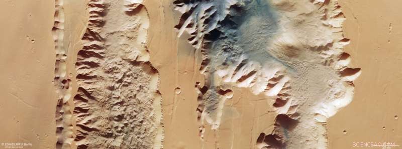
Questa immagine dal Mars Express dell'ESA mostra Ius e Tithonium Chasmata, che fanno parte della struttura del canyon Valles Marineris di Marte. Questa immagine comprende i dati raccolti dalla telecamera stereo ad alta risoluzione (HRSC) di Mars Express il 21 aprile 2022. È stata creata utilizzando i dati del canale nadir, il campo visivo allineato perpendicolarmente alla superficie di Marte e i canali di colore dell'HRSC . È un'immagine "a colori reali", che riflette ciò che l'occhio umano vedrebbe se guardasse questa regione di Marte. La risoluzione al suolo è di circa 25 m/pixel e l'immagine è centrata a circa 272°E/6°S. Il nord è a destra. Credito:ESA/DLR/FU Berlino, CC BY-SA 3.0 IGO
L'ultima immagine rilasciata dal Mars Express dell'ESA ci porta su due rotture nella crosta marziana che fanno parte del potente sistema di canyon Valles Marineris.
La Valles Marineris attraversa Marte come il Grand Canyon attraversa gli Stati Uniti, tranne per il fatto che quest'ultimo è minuscolo in confronto. Con 4000 km di lunghezza, 200 km di larghezza e fino a 7 km di profondità, Valles Marineris è quasi dieci volte più lunga, 20 volte più larga e cinque volte più profonda del Grand Canyon. Essendo il più grande sistema di canyon del Sistema Solare, si estenderebbe dalla punta settentrionale della Norvegia alla punta meridionale della Sicilia.
C'è un'altra grande differenza tra i due:mentre il Grand Canyon si è formato quando il fiume Colorado ha eroso la roccia, si pensa che la Valles Marineris si sia formata attraverso l'allontanarsi delle placche tettoniche.
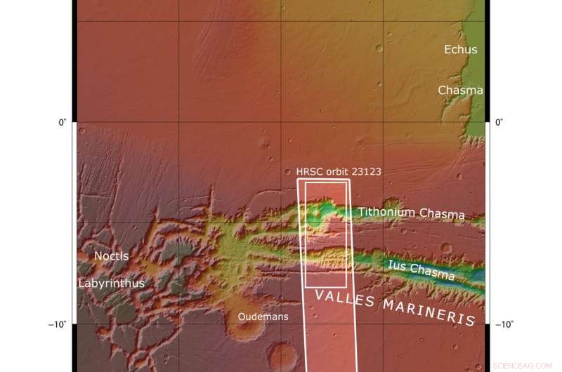
L'immagine mostra due trincee (o voragini) che fanno parte della Valles Marineris occidentale. Sulla sinistra (sud) c'è lo Ius Chasma lungo 840 km e sulla destra (nord) c'è il Tithonium Chasma lungo 805 km. Sebbene queste immagini ad alta risoluzione mostrino incredibili dettagli della superficie, è solo guardando una mappa di elevazione che ci rendiamo conto di quanto siano profondi in modo spettacolare i chasmata, fino a 7 km! A 4809 m, il Monte Bianco, la montagna più alta delle Alpi, sarebbe sminuito se fosse collocato all'interno del Tithonium Chasma.

Questa immagine dal Mars Express dell'ESA mostra Ius e Tithonium Chasmata, che fanno parte della struttura del canyon Valles Marineris di Marte. L'area delineata dal riquadro bianco in grassetto indica l'area ripresa dalla telecamera stereo ad alta risoluzione Mars Express il 21 aprile 2022 durante l'orbita 23123. Credit:NASA/MGS/MOLA Science Team
Nella parte superiore del Tithonium Chasma, una macchia di sabbia scura crea contrasto cromatico nell'immagine. This sand may have come from the nearby Tharsis volcanic region.
Next to the dark sand dunes are two light-toned mounds (one cut in half by the upper image border). These "mounds" are more like mountains, rising more than 3000 meters in height. Their surfaces have been strongly eroded by Mars' strong winds, indicating that they are made of a weaker material than the surrounding rock.
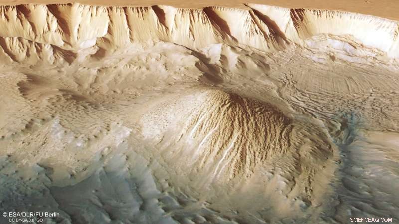
Between the two mounds we see a series of smaller bumps, as shown in the second perspective view. Investigations by Mars Express have found water-bearing sulfate minerals in this region. This suggests that these bumps may have formed when liquid that once filled the chasma evaporated, although this theory is still hotly debated.

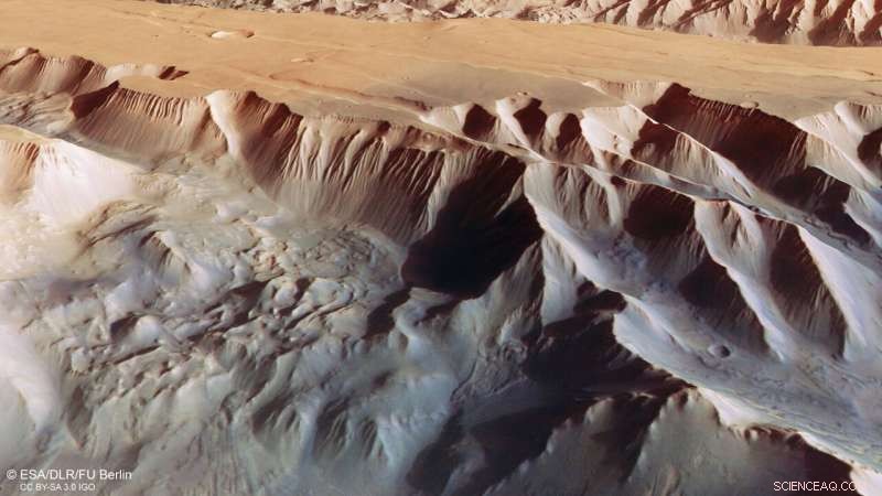
This oblique perspective view of Tithonium Chasmata, which forms part of Mars’ Valles Marineris canyon structure, was generated from the digital terrain model and the nadir and colour channels of the High Resolution Stereo Camera on ESA’s Mars Express. Credit:ESA/DLR/FU Berlin, CC BY-SA 3.0 IGO

This oblique perspective view of Tithonium Chasmata, which forms part of Mars’ Valles Marineris canyon structure, was generated from the digital terrain model and the nadir and colour channels of the High Resolution Stereo Camera on ESA’s Mars Express. Credit:ESA/DLR/FU Berlin, CC BY-SA 3.0 IGO
To the lower right of the mound that we see fully (upper right in the second perspective view), we can see parallel lines and debris piles that indicate a recent landslide. This is also visible as a large purple area in the topography image below. The landslide was caused by the collapse of the canyon wall on the right, and is likely to have occurred relatively recently because it has not been strongly eroded.
The gnarly floor of Ius Chasma is equally fascinating. As tectonic plates pulled apart, they appear to have caused jagged triangles of rock to form that look like a row of shark teeth. Over time, these rock formations have collapsed and eroded.
Exploring Mars
Mars Express has been orbiting the Red Planet since 2003, imaging Mars' surface, mapping its minerals, identifying the composition and circulation of its tenuous atmosphere, probing beneath its crust, and exploring how various phenomena interact in the Martian environment.
The mission's High Resolution Stereo Camera (HRSC), responsible for these new images, has revealed much about Mars' diverse surface features, with recent images showing everything from wind-sculpted ridges and grooves through impact craters and channels that once carried liquid water to volcanoes, tectonic faults, river channels and ancient lava pools. + Esplora ulteriormente